Posts Tagged ‘Long Island Expressway’
correlated causeways
Eleven bridges, one creek.

– photo by Mitch Waxman
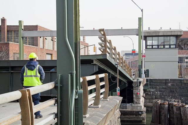
Pulaski Bridge is the first span you encounter, when you’ve left the East River and embarked on a journey down the fabulous Newtown Creek. A double bascule drawbridge, and electrically powered, the Pulaski Bridge connects 11th street in Long Island City with McGuinness Blvd. to the south in Brooklyn’s Greenpoint. Built in 1954, the Pulaski Bridge is owned and operated by the New York City Department of Transportation or “NYC DOT.” The Pulaski Bridge carries five lanes of traffic, plus a dedicated bicycle lane and a separate pedestrian pathway. It overflies the Queens Midtown Tunnel and Long Island Expressway, as well as active railroad tracks found on Borden Avenue.

– photo by Mitch Waxman
DB Cabin acts as a gatekeeper to the Dutch Kills tributary of Newtown Creek. It’s a railroad swing bridge owned by the Long Island Railroad, and connects two rail yards – the Wheelspur Yard (to the west, or left in the shot above) and the Blissville Yard – across the water. Both rail yards and the bridge itself are part of the LIRR’s Lower Montauk tracks. DB Cabin dates back to the 1890’s and is in a terrible state of repair. The swing bridge’s motors are nonfunctional, which isolates the Dutch Kills tributary from maritime traffic, and from the rest of the Newtown Creek.

– photo by Mitch Waxman
Cabin M is just to the north of DB Cabin on Dutch Kills, and the single bascule drawbridge connects the Montauk Cutoff with the Blissville Yard mentioned above. The Montauk Cutoff is an elevated track which used to provide a connection between the LIRR’s Main Line tracks at the nearby Sunnyside Yards with the Lower Montauk tracks along the north (or Queens side) shoreline of Newtown Creek. The 2020 Capital Plan just released by the Long Island Railroad’s owner – The MTA – includes funding to demolish Cabin M.

– photo by Mitch Waxman
Borden Avenue Bridge is owned by the NYC DOT, and is one of just two retractile bridges in NYC (the other being the Carroll Street Bridge over the Gowanus Canal). Built in 1908 to replace an earlier wooden drawbridge (1868) at the intersection of Borden Avenue and Dutch Kills, Borden Avenue Bridge received extensive upgrades and structural repairs in 2010 and 2011, and had its electronic components destroyed by flooding during Hurricane Sandy. Another round of repairs and upgrades began in 2019, which included asbestos abatement work.

– photo by Mitch Waxman
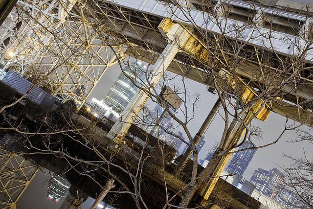
The Long Island Expressway is 71 miles long, and is operationally managed in three sections. The Queens Midtown Expressway is how it’s owners, the New York State Department of Transportation, refer to the section found between the Queens Midtown Tunnel and Greenpoint Avenue in Long Island City. This section is elevated, rising to 106 feet above the waters of Dutch Kills. The LIE truss pictured above handles some 87.7 thousand daily vehicle trips, or 32 million annually, to and from Manhattan,
– photo by Mitch Waxman
Hunters Point Avenue Bridge is due north west of Borden Avenue Bridge and the LIE truss. It’s a single bascule drawbridge, owned by the NYC DOT. Replacing an earlier wooden draw bridge that was opened and closed by a donkey walking on a wheel, the Hunters Point Avenue Bridge was built in 1910. Back then, it was a double bascule bridge, but a rebuild in the 1980’s simplified the mechanism to a single bascule. The masonry of the bridge is original to the 1910 design.

– photo by Mitch Waxman
The Greenpoint Avenue Bridge is found some 1.37 miles from Newtown Creek’s intersection with the East River, and roughly a half mile from the mouth of Dutch Kills. It’s a double bascule bridge, built in 1987, and owned and operated by the NYC DOT. There have been many Greenpoint Avenue Bridges, dating back to the first one built by Greenpoint’s town father Neziah Bliss back in 1850, but that one was called the “Blissville Bridge.” The Greenpoint Avenue Bridge is a traffic machine, carrying 28.3 thousand vehicle trips a day, or about ten million a year. Most of that traffic takes the form of heavy trucking.

– photo by Mitch Waxman
The brand new Kosciuszko Bridge(s) replaced a 1939 vintage truss bridge that carried the Brooklyn Queens Expressway over Newtown Creek and are found some 2.1 miles from the East River. The NYS DOT is busy putting the finishing touches on the new cable stay bridge’s construction. In addition to the… ahem… high speed traffic lanes of the BQE, there is also a pedestrian and bicycle pathway found on the new Kosciuszko Bridge which connects 43rd street in Queens’s Sunnyside section with Meeker Avenue in Brooklyn’s Greenpoint.

– photo by Mitch Waxman
The Grand Street Bridge is a swing bridge connecting Maspeth’s Grand Avenue in Queens with East Williamsburg/Bushwick’s Grand Street in Brooklyn. 3.1 miles back from the East River, in a section of Newtown Creek once called “White’s Dock,” the NYC DOT have recently announced plans to replace this 1909 beauty – which is actually the third bridge to occupy this spot. Damage from Hurricane Sandy, and the narrow roadways with height restrictions that the bridge offers, have pretty much sealed its fate. It will be missed.
This is where the main spur of Newtown Creek ends, as a note. Directly east is a truncated tributary called the East Branch, and another tributary called English Kills makes a hard turn to the south just before you encounter Grand Street Bridge.

– photo by Mitch Waxman
Metropolitan Avenue Bridge is a double bascule drawbridge that crosses the English Kills tributary of Newtown Creek, and is owned by the NYC DOT. Metropolitan Avenue was originally built as a private toll road in 1813, and the first bridge here was a part of the “Williamsburg and Jamaica Turnpike.” The current Metropolitan Avenue Bridge was built in 1931, although it has received significant alterations in 1976, 1992, 2006, and again in 2015. The 2015 alterations?
You guessed it, Hurricane Sandy strikes again.

– photo by Mitch Waxman
Montrose Avenue Rail Bridge is the final crossing found over the waters of Newtown Creek and its tributaries. Some 3.7 miles back from the East River, it’s the property of the Long Island Railroad and used for freight service on their Bushwick Branch tracks. A truss bridge, or trestle if you must, my understanding of things are that whereas the trackway and parts of the rail bridge date back to approximately 1924… there has been quite a lot of work done on the thing which I have not been able to fully document so rather than fill in blanks with assumptions – I’m just going to say that I don’t know everything… yet.
It’s an active track, it should be mentioned.
“follow” me on Twitter- @newtownpentacle
Buy a book!
“In the Shadows at Newtown Creek,” an 88 page softcover 8.5×11 magazine format photo book by Mitch Waxman, is now on sale at blurb.com for $30.
clutching inkiness
Simple things, in today’s post.

– photo by Mitch Waxman
Amongst the first things that one of my neighbors in Astoria wants to know is what zodiac sign you were born under. When you indicate where your birthday lands on the wheel of the year, she shoots a knowing look at you and acts like you just revealed the code you use for the ATM terminals at the bank. It’s made up, astrology is. Bunk.
Another neighbor loudly pronounces that “he doesn’t give a ‘eff” before doing something stupid or self destructive. He’s part of a whole crew I know that doesn’t give an ‘eff about this or that. At my age, the single thing that I’ve gleaned about life is to give lots and lots of ‘effs. Not giving an ‘eff can get expensive, consequence wise. I’ve gotten to the point these days to proactively give ‘effs, just to save some dough.

– photo by Mitch Waxman
Something I use as a gauge of intellect in the people I meet and encounter is whether or not a stressor will cause the phrase “I don’t care, call the Cops, I don’t care” to emerge from their face hole. The statement is meant to elicit fear in the listener, and indicate how “thug,” “street,” or just plain “bad ass” the petitioner is. Usually, the statement is offered as part of a series of aggressive primate display behaviors, with a lot of hand waving and other declarative statements (see paragraph above) wound in.
Nobody, and I mean nobody, doesn’t care when the Cops arrive. If you don’t care when they get there, NYPD will ensure that you do. Me? I do not wish for encounters with people who believe in the efficacious nature of dime store astrological advice and who do not “give an ‘eff” to escalate into requiring the mediating presence of the gendarmes. Seriously… what is wrong with our culture these days?

– photo by Mitch Waxman
Everybody you see is under constant pressure… the rent is due next week, tick tock. This thing is wrong, and that thing hurts for no reason, and the subways, and now that his Presidential Campaign is done the Mayor is going to get back to doing stupid things again… Washington, and the Executive Branch in particular, is currently being staffed by comic book villains. Everybody is under constant existential pressure, and the ropes tighten up a bit every single day. I can see the appeal of embracing the pseudo scientific, supernatural, and behaving as if you were a mafioso when you are… in fact… a dry wall installer or drive a truck or something.
The question I always ask is “what do you want to achieve,” or “what result do I think this particular set of things I’m doing and saying will cause to happen”? Was it my status as a Virgo that caused me to break a car window while screaming “Call the Cops, I don’t care, I don’t give an ‘eff” and did it cause me to act like an asshole when I got my wish and get all aggressive towards them when they show up? Smart move is to give up. A cop on the street has the legal right to kill you, they are god on the street. Starting from the minute that the cuffs go on, and progressing through the arrest process, the street cop becomes less and less godlike. Be smart.
I just don’t understand people. Really don’t. Better to spend my time alone, wandering through the concrete devastations. There are no fortune tellers there, nor vainglorious fools shouting “worldstar.”
“follow” me on Twitter- @newtownpentacle
Buy a book!
“In the Shadows at Newtown Creek,” an 88 page softcover 8.5×11 magazine format photo book by Mitch Waxman, is now on sale at blurb.com for $30.
blossoming orchards
Down under the Long Island Expressway, or DULIE, in today’s post.

– photo by Mitch Waxman
So, after shlepping my tripod setup around Dutch Kills last weekend, I decided that I just wasn’t done yet. Heading east alongst the venerable avenue of Borden, a humble narrator found a few interesting spots to do a “setup” and get clicking. It was DULIE which captured my attention on this leg of the walk.
As mentioned in an earlier post, the LIE and Queens Midtown Tunnel opened for business in November of 1940. The LIE, where it crosses the sediment choked waters of Newtown Creek’s Dutch Kills tributary here in Long Island City, rises one hundred and six feet above the water. This means a lot of steel supports, and an empty corridor found beneath it.

– photo by Mitch Waxman
One is obsessed with this section of LIC, as so much has happened here. The General Electric Vehicle Company complex was just a block away, so were a couple of steel factories. A fossilized rail spur can still be found here and there, winding it way around and between the factories, but the locomotive city is long gone. It’s all about the internal combustion engine in modernity – the automobile city.
The principal proponent of the latter didn’t begin the Queens Midtown Tunnel, he just took it over towards the end of the project and made sure the LIE would be his baby. I’m speaking of Robert Moses, of course.

– photo by Mitch Waxman
The sewer grates up on the LIE connect to long vertical pipes, which just empty out onto the ground, and their flow carries all sorts of “yuck” down into LIC from the expressway high above. There’s meant to be a little concrete spillway which would carry the liquid and solute “spill” into a second grate, one which basically empties into Dutch Kills, but the build up of “crapola” around the pipe creates sickly mounds of toxic soil like the one pictured above.
Hey, I’m not judging, I love places like this.

– photo by Mitch Waxman
As a note, whenever I’m describing an encounter with the Gendarmes or some zealous security guard, I always go on about “there being no law forbidding…” and “if you can see it from the sidewalk…”.
In the case of the other night however – picture this: some weird looking bearded old man standing in pitch darkness on a Sunday night with a camera tripod under the LIE, wearing a reflective vest over a filthy black raincoat – I was ready to converse with somebody wearing a badge about what I was up to. You’d just figure that, right?
The cops though, three cruiser units worth spaced out over the evening, just drove on by me. I mean… I felt suspicious looking. The reflective vest is very good camouflage. Instead of being high visibility as promised, it’s a near invisibility prophylactic against “why are you taking pickchas of dat?”

– photo by Mitch Waxman
One was growing fatigued by this point, it was well after ten, and a humble narrator embraced an ideation about starting out for home. One last long exposure shot from DULIE was executed, and thereupon the tripod kit was folded up into its traveling configuration and a lens swap occurred.

– photo by Mitch Waxman
The lens I’ve been using for the series of night shots recently has been a Sigma 18-300 – which is by definition a “daylight lens, given that at full zoom it’s aperture is only f6.3. Tripod shots, like the ones I’ve recently been producing, make the usage of extremely narrow apertures possible – which in turn allows for a deep field of focus. Impossible for handheld usage in low light, however, this lens is. It’s singular virtue is the zoom range, ultimately. I’ve got better lenses, including a different Sigma, but this particular specimen allows me to carry just one lens.
I’ve always got a “nifty fifty” lens in my bag, however, which allows me to open up the aperture to f1.8, allowing a lot more light in. That’s the one I snapped onto the camera, which coincidentally lightened the gizmo by about a pound and a half. Lotta glass inside that Sigma, but you don’t really feel the weight of it when it’s in the bag.
“follow” me on Twitter- @newtownpentacle
long miles
Borden Avenue Bridge and environs, in today’s post.

– photo by Mitch Waxman
There have been three Borden Avenue Bridges, the first being a wooden draw bridge that opened when Borden Avenue was created in 1868. It was replaced by an iron swing bridge which was demolished in 1906, and the modern day retractile bridge was opened on the 25th of March in 1908. It cost $157, 606 to build in 1908. That would be $4,365,073 in modern money, adjusted for inflation.
A bargain, no?

– photo by Mitch Waxman
Borden Avenue Bridge is one of only two retractile bridges in NYC, the other one being the infinestimal Carroll Street Bridge over the Gowanus Canal. This specie of movable bridge is actually quite common in other cities, notably Chicago.
Chicago ain’t got a view like the one above though, I’d wager.

– photo by Mitch Waxman
To the south of Borden Avenue, one might notice the two railroad bridges spanning Dutch Kills – Cabin M and DB Cabin. The latter carries traffic for the Lower Montauk Branch of the LIRR from the Wheelspur to Blissville Yards, all of which which are mainly used for freight these days. Cabin M connects to the Montauk Cutoff, a now severed connection to the Sunnyside Yards and the LIRR Main Line tracks.
Just beyond the two rail bridges is the main body of Newtown Creek.
– photo by Mitch Waxman
Dutch Kills itself, in this area around the Borden Avenue Bridge, is stagnant and choked with wind blown garbage. A tepid current in the water creates a vertical rather than horizontal flow pattern, which factors into the accretion of sediments on the bottom. These sediment beds, which are found across the entire Newtown Creek watershed and represent a centuries long cross section of industrial and municipal pollution, are the reason that the Creek and its tributaries are a superfund site.
At low tide, mounds of this material become exposed to the air.

– photo by Mitch Waxman
For many years, there was a shanty dwelling here, occupied by some unknown entity. Hurricane Sandy ended that tenancy.

– photo by Mitch Waxman
My chosen path next carried me eastwards on Borden Avenue, away from my beloved Creek and deeper into the post industrial landscape of Long Island City. The concrete devastations were calling to me.
“follow” me on Twitter- @newtownpentacle
beaten man
It’s National Coffee Ice Cream Day, in these United States.

– photo by Mitch Waxman
Wandering around Long Island City with the camera is kind of “my thing.” Ordinarily, I’ve got one of my H.P. Lovecraft audiobooks blaring away in my headphones. More often than not, there’s some destination at Newtown Creek I’m heading for, as I was when these shots were gathered. On this particular day, I front loaded some “wander” time into the equation which allowed me to take a rather circuitous route to my eventual destination over in Brooklyn’s Greenpoint section.
I also wanted to “check in” on an area which I’ve not visited in the last few months to see if anything novel was happening. This area would be best described as the “angle” between Sunnyside and Blissville along Van Dam Street.

– photo by Mitch Waxman
There’s three moments in the history of LIC’s Van Dam Street to take note of. One occurred in 1909 when the Queensboro Bridge began to feed vehicular traffic into “Queens Plaza,” another was in 1914 when the newly consolidated City of Greater New York funded a project to raise the grade of Van Dam street several feet in elevation, and the other was in 1940 when the Long Island Expressway opened. The 1917 appearance of the IRT Flushing Line subway service on what was Thomson Venue but was soon renamed “Queens Blvd.,” is also kind of important (this was about 1921, I’m told).
Van Dam is angled against the street grid of the Blissville section of LIC, but its generally north/south path leads to Greenpoint and North Brooklyn from its start at Queens Blvd. Apparently, there used to be trolley service on Van Dam, which was a part of the Steinway Line. The street is named for the Van Dam family, which was quite prominent in both City and the future State back in the 17th and 18th centuries. One of them, Rip Van Dam, was the governor of the British owned New York colony from 1731-2.

– photo by Mitch Waxman
Robert Moses didn’t start the Queens Midtown Tunnel or Long Island Expressway projects, but by the time they both opened for business in August of 1940 they were firmly a part of his empire. It took four years to build the tunnel itself, and the high speed road that snakes into it runs eastwards for some seventy one miles. As you can see from the shots above and below, not much thought was paid into what would happen to the runoff from the highway.
It just splatters down onto LIC and into the sewer grate.

– photo by Mitch Waxman
This is nothing unusual, and I’ve been informed by the powers that be that not one of NYC’s many bridges, tunnels, or highways is directly connected to a sewer plant – even the brand new Koscisuzcko. Rather, they all just feed into storm sewers, which then release into area waterways. The world is a joyful place, for one such as myself.

– photo by Mitch Waxman
This section of the Long Island Expressway, officially known as the Queens Midtown Expressway, carries an average of 80,000 vehicle trips a day to and from the Queens Midtown Tunnel. That’s 29.2 million vehicle trips annually.
Upcoming Tours and events
Calvary Cemetery Walking Tour, with Atlas Obscura – Saturday, September 9th, 11 a.m. – 1 p.m.
Explore NYC history, hidden inside sculptural monuments and mafioso grave sites, as you take in iconic city views on this walking tour, with Newtown Creek Alliance Historian Mitch Waxman – details here.
“follow” me on Twitter- @newtownpentacle


