Archive for the ‘Newtown Creek Alliance’ Category
the First Big Announcement

– photo by Mitch Waxman
Your humble narrator will be conducting a walking tour in Long Island City as part of the Open House NY Weekend on October 15 and 16. The tour will be approximately two hours in length, starts at 11 am, and will visit several of the amazing industrial landmarks which distinguish the Queens side of the Newtown Creek Watershed. Much of the walk will follow the Dutch Kills tributary of Newtown Creek. Reservations are required, which can be had by visiting the following link:
http://www.ohny.org/site-programs/weekend/programs/walk-down-newtown-creek
Oh, did I neglect to mention that this walking tour is free, as in gratis, as in no cost to you- Lords and Ladies?

– photo by Mitch Waxman
This is the first of two big announcements, the second is still under wraps and I’m not able to discuss it at this point. Hopefully, within the next couple of days, I’ll be able to say more. Open House NY weekend is a citywide event, and there are multiple opportunities to do cool and unique things. Please check out the rest of their offerings, but you definitely want to come on this exploration of a hidden and neglected waterway which is found less than one mile from midtown Manhattan.

– photo by Mitch Waxman
Bring a camera, of course, but I would be remiss if I didn’t advise you that broken pavement and largish puddles might be encountered- so proper (closed toe) footwear is advised. Additionally, this is as close to an urban desert as you are ever likely to find, so if you are one of the folks who likes to “stay hydrated”, bring a beverage along. Sparks deli on Borden Avenue will most likely be open, but one never can tell. Looking forward to seeing you along the Dutch Kills, and as always-
Want to see something cool?
Bring a camera, and ID…
Follow me…
…hits the fan

– photo by Mitch Waxman
Council Member Van Bramer sent this out to his mailing list today, regarding Hurricane Irene
As everyone knows by now, Hurricane Irene is expected to hit our area sometime Saturday into Sunday. We should all take precautions to be prepared for a storm of this magnitude. Some areas in our district are in evacuation zones and at high risk for flooding. Those areas of Hunters Point/Long Island City should familiarize themselves with the map below and know that should an evacuation be ordered, Newcomers High School (28-01 41st Ave.), Aviation High School (45-30 36th St.) and W.C. Bryant High School (48-10 31st Ave.) are your nearest evacuation centers. The City will make a decision about whether to order a mandatory evacuation of Zone A for the general public by 8:00 AM on Saturday. The evacuation centers will be open as of 5:00 PM today and the City is strongly recommending that people within these areas immediately make plans to go to alternative locations outside of Zone A starting tomorrow for the duration of the storm. The orange areas are Zone A. The yellow areas are Zone B. The green areas are Zone C.

We are also concerned about significant portions of the district including parts of Sunnyside, Woodside, Astoria and Maspeth that have experienced flooding during several recent storms. Our office has been and will continue to be in contact with the Department of Environmental Protection (DEP) and other city agencies throughout this weekend. Anyone experiencing difficulties as a result of Hurricane Irene should contact me and my office as soon as they occur. We will report problems in real time. For those outside of Zone A areas that have experienced flooding or are concerned that you may, please click on the link below on how to protect your valuables. In addition to calling our office, DEP is asking for reports of flooding to be called in to 311.
http://home2.nyc.gov/html/oem/downloads/pdf/flooding_guide.pdf
I have also been in touch today with NYCHA and the Mayor’s Office to make certain that Queensbridge, Ravenswood, and the Woodside Houses are included in any and all emergency plans including evacuation, should that be necessary. We will continue to be in regular contact with NYCHA throughout the storm.
While we continue to hope for the best, we must prepare for the worst. The city has published some useful information in securing your home during the storm. Please click on the link below for recommendations on how best to prepare for the hurricane.
www.nyc.gov/html/oem/html/ready/hurricane_guide.shtml
Given the high volume of traffic to OEM’s (Office of Emergency Management) website there have been delays and interruptions in gaining access to some of these links. For that reason, we also include the Red Cross’ Hurricane Safety Checklist below. We have also included information from OEM’s Hurricane Guide at the end of this email should that link not respond when you try it.
http://www.redcross.org/www-files/Documents/pdf/Preparedness/checklists/Hurricane.pdf
In advance of the hurricane I wanted to remind you that clogged catch basin grates can aggravate flooding. Although DEP staff – with the help of their colleagues at other agencies – are busy cleaning catch basins now, DEP has asked us to remind homeowners and residents that they welcome assistance in removing leaves, litter or other debris that may prevent water from flowing off the streets and into the catch basins. For any of you that aren’t familiar with catch basins the attached link to a page on DEP’s website has some text and visuals that will help explain why flooding occurs and how citizens can help DEP minimize flooding by removing debris where they see it blocking catch basin grates.
http://www.nyc.gov/html/dep/html/flooding/flooding_causes.shtml
I will be keeping my district office open on Saturday to field questions and concerns from constituents. Needless to say, we will close the office when the storm approaches and will reopen as soon as it is safe to do so. My district office number is (718) 383-9566. I will be in the district throughout the storm and encourage anyone with problems to email me concerns at jvanbramer@council.nyc.gov as well as using social media including Facebook (http://www.facebook.com/jimmyvanbramer) and Twitter (http://twitter.com/jimmyvanbramer) to reach me. You may also call 311. Please only call 911 if you have a very serious or life threatening emergency.
I hope this update and the attached information proves useful to you. Again, my staff and I will be working throughout the weekend and please do not hesitate to contact me should you need assistance.
Sincerely,

Jimmy Van Bramer
Council Member

– photo by Mitch Waxman
Additionally, the Council Member included the following information from the Office of Emergency Management
OEM’s Hurricane Guide
To secure your home if a tropical storm or hurricane watch is issued:
Bring inside loose, lightweight objects, such as lawn furniture, garbage cans, and toys.
Anchor objects that will be unsafe to bring inside, like gas grills or propane tanks. Turn off propane tanks.
Shutter windows securely and brace outside doors.
Place valuables in waterproof containers or plastic bags.
Help Others Prepare
- Check on friends, relatives, and neighbors, especially those with disabilities or special needs, and assist them with their preparation and evacuation.
- If you live outside an evacuation zone, offer to shelter family and friends who may need to evacuate.
If Asked to Evacuate, Do So Immediately
The City will communicate specific instructions about which areas of the city should evacuate through local media. If the City Issues an Evacuation Order for Your Area: Evacuate immediately. Use public transportation if possible.
If you are going to an evacuation center, pack lightly, and bring:
- Your Go Bag
- Sleeping bag or bedding
- Required medical supplies or equipment
- Let friends or relatives know where you are going.
What about my pets?
- Make sure your disaster plan addresses what you will do with your pet if a hurricane requires you to leave your home.
- Plan to shelter your pet at a kennel or with friends or relatives outside the evacuation area.
- Be sure you have supplies ready for your pet in the event of an evacuation, including food, a leash, a muzzle, proof of shots, and a cage or carrier.
Account for your special needs
- Consider your capabilities and make sure your preparedness plan addresses how your special needs affect your ability to evacuate and shelter.
- Determine if you will need assistance and arrange help from friends, family, or neighbors.
- Consider additional supplies and equipment that you may need to bring with you, such as medicine, icepacks, medical devices, and backup equipment. Bring food for your dietary needs.
- Include additional time and evaluate your transportation options.
IF YOU LIVE IN AN EVACUATION ZONE
Prepare A Disaster Plan
Develop a plan with your household members that outlines what to do, how to find each other, and how to communicate if a hurricane strikes New York. If you rent your home, renter’s insurance will insure the items inside your apartment. If you are a homeowner, make sure your home is properly insured — flood and wind damage are not covered in a basic homeowner’s policy.
Know Where You Will Go
The City strongly recommends evacuees stay with friends or family who live outside evacuation zone boundaries. For those who have no other shelter, the City will open hurricane shelters throughout the five boroughs.
To ensure efficient use of resources, the City will ask all evacuees to report to an evacuation center. Once at the evacuation center, evacuees will either be assigned to a hurricane shelter in the same facility or transported to an associated hurricane shelter by bus.
Every household member should have a small Go Bag — a collection of items you may need during an evacuation packed in an easy-to-carry container such as a backpack. A Go Bag should be easily accessible if you have to leave your home in a hurry.
Assemble an Emergency Supply Kit
You may be instructed to shelter in place (stay at home) during a hurricane. Keep enough supplies in your home to survive for at least three days.
If you do not live in an evacuation zone
All areas of the city could face hurricane-related hazards such as high winds, flooding, tornadoes, and loss of utilities. You may be instructed to shelter in place (stay at home) for several days until the hurricane passes.
If you live in a high-rise apartment building
Residents of high-rise apartment buildings may face special risks from hurricanes even if they live outside evacuation zone boundaries. If you live in a high-rise building outside an evacuation zone, be prepared to take shelter on or below the 10th floor. If you live in a high-rise building located in an evacuation zone, heed evacuation orders.

– photo by Mitch Waxman
This looks like it will be a profound event. Personally, I’m preparing for an uncomfortable few days, but that’s because I live inland and uphill in Astoria. Long Island City and Greenpoint on the other hand…
Our friends at liqcity.com have prepared an excellent posting on the Zone A situation, which can accessed here:
http://www.liqcity.com/life/long-island-city-and-hurricane-irene-a-match-made-in-well-well-see

– photo by Mitch Waxman
Newtown Creek Alliance, an organization of which I’m a member, issued this statement earlier today…
Flood Warning for Creek Neighborhoods
Mayor Michael Bloomberg announced on August 25th, 2011 that certain emergency measures will be instituted in low lying coastal districts referred to as “Zone A” (at high risk of coastal flooding) due to the expected arrival of Hurricane Irene in the New York City area late Saturday night. Much of the land surrounding Newtown Creek is designated as “Zone A” on the coastal flooding map prepared by City officials, including large tracts of Greenpoint and Long Island City. For a map of the affected areas, please click here.
Newtown Creek Alliance cautions residents of the affected areas to monitor the situation and be prepared to evacuate should authorities warrant it necessary. If an evacuation is recommended or ordered, information about evacuation centers and hurricane shelters may be found by calling 311 or at by visiting this website. Additionally, be mindful that during such an event, the flood waters could carry a significant load of pollutants and should not be ingested. Care should be taken upon any contact with skin.

– photo by Mitch Waxman
Sources within the City have discussed this storm with me in the most dire tones. If you live in an area designated for evacuation, please comply. I’ll be marching out into the brave new aftermath early Monday morning, if there’s something which you think I should point my camera at, please contact me here. Good luck, and assuming the availability of both electrical power and internet connectivity, I’ll post as the situation develops.
As this post was being prepared, Council Member Van Bramer passed along another message, ordering the mandatory evacuation of Zone A by 5 pm Saturday.

gleaming vividly

– photo by Mitch Waxman
An unusually personal posting today-
A continuing fascination with the complexities of maritime photography has taken up quite a bit of my summer in 2011. Tugboats, in particular, demand attention whenever I’m on or near the water. It probably has to do with having recently sold a couple of tug shots to the NY Times, illustrating an article in the weekender section profiling the Working Harbor Committee.
When you get paid for something you enjoy doing, life attains symmetry and seems to have a purpose, especially when the people writing the check are “the paper of record”.

– photo by Mitch Waxman
As has been my habit since childhood, late summer is when I assess “how it’s going”, figure out what isn’t working in my life and try to formulate a plan to get “back on track”. It’s been a great few months: working with Forgotten-NY and Greater Astoria Historical Society on their ambitious “2nd Saturday” series of tours, assisting the Working Harbor Committee with their multitudinous tours and events, helping design and produce an event for the New York City Centennial Bridge Commission, and conducting my own boat tours of Newtown Creek for Working Harbor and Metropolitan Waterfront Alliance’s City of Water Day. I’ve also presented the Magic Lantern show three times this summer- at Greater Astoria Historical Society, City of Water Day, and at a DEP event.
Additionally, Newtown Creek Alliance’s various events, presentations and public meetings have kept me quite busy. However, in the midst of working with all these wonderful people, my own operation and schedule has been damaged by inattention.

– photo by Mitch Waxman
One thing which is foremost in my mind, and which will be rectified in the coming weeks and months as we slouch toward fall and winter, has been the irregular schedule of postings here. Apologies are offered, contradicting my normal credo of “never complain, never explain”, but this blog is essentially a one man operation (although special kudos go out to Our Lady of the Pentacle and Far Eastern Correspondent Armstrong for unbelievable effort and support). Massive effort is underway to resume a normal and regular schedule of postings.
There will be one more HUGE announcement coming about a Newtown Creek event I’ll be offering in October, but I’m contractually obligated to not be more specific about it than that.
In short… Back in session.
another aperture

– photo by Mitch Waxman
An aerial shot from the former Loose Wiles biscuit factory (and modern day LaGuardia Community College) which shows the totality of the Dutch Kills turning basin and the properties which surround it. Special notice of the cement factory and the red white and blue self storage warehouse should be taken, and the Hunters Point Avenue Bridge and Long Island Expressway (just above center) which were described in earlier posts are also pointed out. Additionally, notice the two sunken barges in the lower left hand corner of the shot.
click for parts one, two, and three of this trip down Dutch Kills. This is the last of the four postings describing what I saw at Dutch Kills while on a Newtown Creek Alliance assignment.

– photo by Mitch Waxman
The stated mission of this exhibition was to catalog and photograph the little known bulkheads and shorelines of Newtown Creek and it’s various tributaries, and NCA had arranged for Riverkeeper to ferry us back and forth across the troubled waterway. Troubled is a politically correct way of describing the Newtown Creek watershed which native New Yorkers would translate into local patois as “all ‘effed up”, or which a military man would call “FUBAR”.

– photo by Mitch Waxman
Risible, the state of decay along these shorelines is startling. Dutch Kills has been largely abandoned by maritime interests, despite its once proud role as the central artery of the industrial complex called the Degnon Terminal. The corrosive affect of estuarine water upon cement and underlying steel has rotted away the manmade shorelines and bulkheads, carving away the efforts and labor of whole generations.

– photo by Mitch Waxman
There is no reason to say the name of the corporation which occupies the red, white, and blue self storage warehouse which sits above these pilings. It is immaterial to adjure any organization in Queens, whether it be governmental or corporate, for no one cares. It is remarkable, though, that the corrosive action of the waters of Dutch Kills have so undermined the foundations of this structure that grottoes have formed amongst its pilings.

– photo by Mitch Waxman
Remember, this was swamp land as late as the first decade of the 19th century. When Degnon’s people began their work here, at the Waste Meadows, there was barely any solid land between Hunters Point and Blissville. The LIRR, of course, had built their tracks sturdily and have no doubt that Standard Oil had engineered their grounds with proper drainage and stout foundations- but the inland path along Dutch Kills was nearly worthless.

– photo by Mitch Waxman
Degnon owned a construction company which was capable of doing the impossible, and his people had a special affinity for problems involving water. They made their name during the construction of the second East River (or Williamsburg) Bridge, were involved in the taming of the Wallabout Creek, and had recently been engaged by the newly consolidated City of Greater New York to complete the rail tunnels which would link Queens to Manhattan via the novel new Subway system. Those tunnels excavated a large amount of spoils and borings, which would be used to create the very ground around Dutch Kills as “landfill”.
By the first decade of the 20th century, enough compacted landfill was here to begin pouring concrete slabs, and upon those slabs the Degnon Terminal rose.

– photo by Mitch Waxman
This post will not cover the entire story of the Degnon Terminal. I would refer you to trainsarefun.com, and forgotten-ny for facets of the story, or suggest a visit to the Greater Astoria Historical Society for an attempt to get them to share their expertise on the subject. The tale of Michael Degnon is the stuff of scholarly dissertation. Degnon is buried in Calvary cemetery, and I suspect he rests uneasily because of what lesser men have done to his legacy.
There are two sunken fuel barges here, rusting away into history.

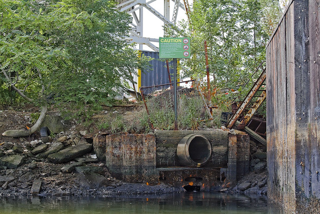
– photo by Mitch Waxman
Pictured above is the CSO Outfall BB-026 which vomits untreated storm water and sewage into Dutch Kills regularly, and it is one of the primary sources of water flowing into Dutch Kills. The boat began moving in a counter clockwise fashion at this point, swinging away from the 29th street address of the red, white, and blue self storage warehouse and toward the concrete factory.

– photo by Mitch Waxman
I’m unfamiliar with the role and identity of the two large pipes which are found beneath the concrete facility. The enormous slab of cement the factory is situated upon was once a rail switch, where short trip rail engines would await incoming barges. Once unloaded, these short trains would make deliveries to the industrial concerns which surrounded Dutch Kills.
Apparently, no small amount of conflict has arisen between the concrete company and environmental watchdogs over the years, but your humble narrator makes it a point of staying out of this sort of thing.

– photo by Mitch Waxman
The concrete industry around Newtown Creek often has fingers pointed at it, but again, large industrial concerns need to be sited “somewhere” to serve the interests of Real Estate and construction. The goal of many, including myself, is to ensure that in the days following the EPA Superfund cleanup of the Creeklands is that industry still feels welcome here. White collar corporate jobs are not an option for many, which is something often forgotten by those who spend their days in air conditioned Manhattan offices imagining the future of Queens.
These dirty industries must be compelled to “clean up their act” but cannot be regulated out of business.

– photo by Mitch Waxman
The boat turned away from the north eastern bulkheads of the Dutch Kills Turning Basin and we explored the bulkheads of the southern abutment. Again, the waters had carved into the underpinnings of the engineered ground. More abscesses and grottoes were observed cut into the cement and the visible wood seemed spongy and softened from the action of unknowable forms of microscopic life.

– photo by Mitch Waxman
I had to “bust a move” to conquer the deep shadows of early morning light here, as the merciless and burning thermonuclear eye of god itself was shining down unoccluded by cloud or atmosphere at this point. An external flash was attached to my trusty camera, which was “bounced” off the water. Anomalously, the green water created orange and red shadows in the reflected bursting of light.

– photo by Mitch Waxman
The Riverkeeper Captain who acted as our boatswain, John Lipscomb, checked his watch and announced that we had to beat a hasty retreat as the tidal actions of the East River would soon cause Dutch Kills to rise. Fearing that we might be trapped in Dutch Kills for a long interval, and having completed only a tiny fraction of our mission, Captain Lipscomb set course for the larger vessel which had launched our tiny “Tin Boat” which was docked at Whale Creek.

– photo by Mitch Waxman
The physical effects of the air and environment here were enormous, but the effort and risk of the journey were worth undertaking. Long have I desired to see Dutch Kills from water level, and to see the place as few others have.
ethereal character

– photo by Mitch Waxman
The launch we were in had been referred to as the “tin boat” by the Riverkeeper folks, but it was more a smallish rowboat with an outboard engine than anything else. This is the second post of this adventure, click here for the first one.
We had just passed beneath the two rail bridges which vouchsafe and isolate Dutch Kills from the main body of the Newtown Creek, and were heading in the general direction of Queens Plaza when we approached the Borden Avenue Bridge.

– photo by Mitch Waxman
Of course, this century old structure has recently undergone a radical schedule of repairs when it was discovered that one of its abutments had begun to shift, and no small amount of complaint arose at the inconvenience from the legions of truckers and ordinary drivers who mourned its unavailability.
Down on the water however, things were pretty intense, from a purely existential point of view.

– photo by Mitch Waxman
Those bubbles of gas mentioned in yesterday’s post, which were erupting even when the water was unmolested by our passing, delivered a slightly petrochemical smell when they burst. Another member of the Newtown Creek Alliance who was sitting next to me in the boat began muttering “Oh my god” over and over at this point in time.
It wasn’t fear in his eyes, it was disbelief.

– photo by Mitch Waxman
My companion was no virgin or first time visitor to the Creek, of course, in fact his experience of the place is broad and far reaching. When all of your senses get involved with the atmosphere of ruination here, however, one tends to become a bit overwhelmed as your brain attempts to interpret and process the impossible data it is presented with.
The canalized bulkheads of Dutch Kills also tower over you from the water level, creating a sense of forced perspective and inevitability.

– photo by Mitch Waxman
The first thing you see when passing the Borden Avenue Bridge is an archaic sewer outfall, and were the brush not at it’s mid summer height, one would observe the shanty home of the Blue Crow above.
For those of you not familiar with this term, Crow is a name assigned in my little section of Astoria to the myriad metal and refuse collectors known to haunt the neighborhood on “Bulk Pickup Day”. Leave something shiny on the sidewalk, a crow will sweep in and grab it.
Metals are collected and sold by the pound in the scrap and recycling markets of Greenpoint and Long Island City, and these guys make their living from hunting and gathering. I assign them color names based on vehicle, or clothing choices.
There’s also a red crow out there.

– photo by Mitch Waxman
Here is a winter shot from road grade level which shows the sewer and the ever expanding hut of this particular crow. There is a photo of him to be in this Newtown Pentacle posting from February of 2010. Don’t be mistaken, I am not insulting either his industriousness or tenacity, if I were in a similar situation things would go far worse for your humble narrator. This man has been surviving in what has to one of the world’s most extreme environments for years now, and rent free.

– photo by Mitch Waxman
Looking back toward the Borden Avenue Bridge, the ominous humming which echoed along the bulkheads and emanated from above signaled that we had passed under another of the bridges of Dutch Kills. This bridge was built high, and called an expressway by Robert Moses himself.

– photo by Mitch Waxman
Some 106 feet over road grade, the high flying Queens Midtown Expressway leg of the larger Long Island Expressway feeds into the yawning mouth of the Queens Midtown Tunnel less than a mile from here. I call this part of Dutch Kills DULIE, or Down Under the Long Island Expressway.
One of the common complaints heard by eastern bound commuters in the early days of the 20th century was about the horrible smells they encountered when crossing through Long Island City. Moses built his auto bridge as high as engineering and budgetary considerations allowed in response to the plume of industrial outgassing which distinguished a trip through the area in his time.

– photo by Mitch Waxman
Dutch Kills is a particularly important tributary of the Newtown Creek, from an industrial history point of view. What is today a relict of brown fields, industrial spills, and toxic leave behinds was once the economic and manufacturing heartland of New York City. The heavy infrastructure here is no accident, and the waterway was a critical feature that drew one of the great (and largely forgotten) men of Queens to the Waste Meadows at the start of the early 20th century.

– photo by Mitch Waxman
At the end of the 19th century, none of this was here. Sure, there was a muddy road made of creosoted wood blocks and riprap bulkheads called Hunters Point Avenue which ran between isolated industrial sites, and a slightly more modern causeway called Borden Avenue which hosted a few large operations, but this was a swampy and pestilential bog. Brackish creeks wound along knolls of marsh grass and the stubby trees held together mud islands.
The place was lousy with all the junk floating down from Blissville and the sewers in Brooklyn and only Mosquitos and ticks found the place hospitable.
Dutch Kills needed to be fixed.
– photo by Mitch Waxman
Another sewer outfall is found directly after passing the LIE’s massive footing, which is the sort of improvement that benefited somewhere else rather than Dutch Kills. It was decided by the city fathers in the first years of the 20th century that something had to be done with these swampy wetlands, so close to Manhattan and the gold coast of the Newtown Creek.
Something was needed- a plan with vision, executed by someone who understood the byzantine politics of Tammany Hall and the recently consolidated City of Greater New York. Additionally, it would have to someone with proven “know how” who could “get it done”.

– photo by Mitch Waxman
From the mid 1930’s on, that person would have been Robert Moses. The ultimate political fixer, Moses employed the greatest engineering minds of a generation to shape and design our modern City. While Moses was still in diapers, however, no shortage of great men existed in the City. A plan was presented, and approved, and in both Albany and Washington- strings were pulled by the Tammany men and budgets were approved.
The Army Corps of Engineers were assigned here to canalize, deepen, straighten and erect industrial bulkheads at Dutch Kills in 1914. Land was reclaimed by dumping the fill and spoils produced by the digging of the Belmont Subway Tunnels (leading to to Manhattan) amongst wooden pilings driven deeply into the mud.
The modern shoreline of Queens began to assume it’s current shape.

– photo by Mitch Waxman
It is apparent what happened here, when you see the Hunters Point Avenue Bridge appear before you.
Progress had arrived in Queens, and his name was Michael Degnon.


